
Back to Pu’u Kaua. And beyond. Specifically to Kolekole Pass. Met up with Brian, James, John, Jose, Matt and Marvin on Kunia Road.

Keep on trucking
Plan A was to have Troy drop us off inside the farm. Marvin’s idea to save us some walking time. Photo by Troy Solano.

Parlez-vous francais?
Honest Abe is not welcome here. I don’t care if he has a twin. Don’t get friendly with the goats either. Parlez-vous NO? Back on the road again.

Plan b
These shoes were made for walking. Thanks for the five minute ride Troy!

The road isn’t so bad
We made our way to the trailhead without further incident.

Up the trail
Wet leaves on the trail was the only difference from last week. Same scenery, more slippery.

Pu’u Kanehoa in the distance
Looking out towards the Waianae Summit Trail.

Pu’u Kaua summit
Back on top for the second time in as many weeks. Group photo left to right: Jose, James, myself, Brian, Marvin, Matt and John.

Pu’u Kaua summit view
Click here for the larger image.

Follow the fence?
I didn’t know goats and pigs could run up the sides of mountains. Learn something new everyday.

Left side
We started hiking on the left side of the fence.

Right side
Terrain shifted, so we switched to the right side.

Which side?
And switched back again.

Take your pick
Most of us climbed over the rock face. James and Marvin decided to contour on the Kunia side which put them closer to the edge. Nice drop. Nice fence.

The easy part
Climbing down this short stretch put us close to the edge, so we used webbing coming down.

Gorilla Head #1
Jose going up the first obstacle dubbed “Gorilla Heads” or “Kriangles” by other hikers.

My turn
Have to work on that tan line. Photo by Matt Vidaurri.

Gorilla Head #2
Jose sitting on the smaller “Gorilla Head.”

Coming down
Coming down the crumbly backside and finding foot holds at the bottom was the hardest part of the “Gorilla Heads.” Photo by Jose Delaki

Looking down
Don’t drop that camera. Might bounce off Marvin’s head. Hmm. Tempting target. Photo by James Crabb.

Looking back
Bark is worse than the bite.

Hiking forward
Brian and John going down the second “Gorilla Head.” Yawn.

Hello?
We briefly talked to a guy that had come up a spur ridge. He was asking too many questions. Possible goat herder.

Boulder contouring
Marvin and James coming down the smaller “Gorilla Head.”

O Christmas tree
A lone Sugi Pine Tree stood out. Resisted the urge to decorate.

Goodbye “Gorilla Heads”
You were fun. Until we meet again.

Hello overgrowth
From the “Gorilla Heads” until Pu’u Kanehoa, the trail was unbearably overgrown.

Hands and knees
A tree is worth a thousand branches. Or more like a thousand pokes.

Exposed
Rain replaced the overgrowth on the trail. Brian was secretly cheering the inclement weather.

More rock climbing?
Nope. Just more contouring to the right.

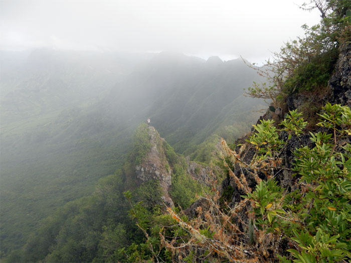
Misty mountains
We all admired the mountains keeping the clouds at bay. Postcard picture. If it only could have kept the rain at bay too. Click here for the larger image.

Pu’u Kanehoa
Cloudy summit view at 2,778′ elevation.

Cloud free
Nobody wanted to stand up for the group photo.

Not this side
Except Matt.

Come on down
Tick tock. Brian is waiting.

So many rock faces to climb and so little time
Abundant rock climbs were sprinkled along the trail. Climb or contour. Take your pick.

Panoramic view
Click here for the larger image.

Can you see us?
The views alternated between cloudy and partly cloudy, with chances of rain showers. Photo by Matt Vidaurri.

All fences lead to the summit
At least this one did.

Up here
Looking up at the summit of Pu’u Hapapa. Long time no see.

Pu’u Hapapa
You say Hapapa, I say Hana Pa’a. Cool view from 2,883′ elevation. Gone were the army men that once ringed the summit.

Camouflage
Unusual coloring for a lady beetle.

Happy face spider?
Not happy at all.

Say what?
Leave your ATVs at home when you do this hike. Fair warning.

Don’t slip here
A nasty case of trail erosion. Nasty for the hiker if they slip and fall.

One way ticket
Down. Straight down. Several thousand feet. Photo by John Garrity.

Going down the ridge
Headed down towards Kolekole Pass.

Panoramic view
Click here for the larger image.

Panoramic view
From sea to shining sea. Click here for the larger image.

Panoramic view
Clouds have cleared. Click here for the larger image.

Enough with the picture taking. Hike on.
We spent a considerable amount of time just soaking in the views and recording them for posterity. It was nice up here. Wouldn’t mind coming back again.

Climbing down the small notch
The group climbing down the first and smallest notch.

Looking back
Matt making his way down.

Climbing out of the notch
Jose climbing out of the first notch.

Going down the big notch
There are two ways to tackle the second and biggest notch. Easy way is contour to the right and the hard way is straight down the rock face. Take your pick.

Silhouette
Jose standing on the exposed dike.

Looking back
Looks bigger in person.

Going down
Scooting down the red dirt.

Meadow
Brian, Jose and John checking out the notches we had come down in the middle of a meadow overlooking central Oahu. Click here for the larger image.

Off with his head
Kolekole Pass Rock or Pohaku Hupeloa, supposedly once used for sacrificial purposes.

Heed the sign
The trail going down was slippery with pine needles.

See!
James did an excellent save and recover. I was not so lucky. Had a hard fall on my butt.

Hitchhiker
We saved this invasive critter from a horrible fate. She was trying to crawl up Marvin’s shorts.

Off duty?
100% ID check in progress.

Where’s our ride?
The original hike was supposed to end in Waianae, where I had staged my truck. Since that proved to be too ambitious, we came down Kolekole Pass and decided to terminate the hike. Matt arranged for his father to pick him up at the gate and then retrieved his truck in Kunia and came back to get us. Thanks Matt!

GPS Tracks
Our hike today was 7.9 miles through some of the most stunning scenery on the Waianae Mountains. Post hike meal was at Outback. Herb roasted prime rib for dinner. Yum! Congrats to Marvin for finishing the WST. I’m next. I hope.
{ 5 comments… read them below or add one }
Was a great hike…and right on with your leadership. Scary parts during the sketchy but we were a good team, and all made it out safely with pretty much no scratches…
Howzit John,
Haha. What leadership? But glad we all had fun and everybody did great!
Mahalo
Well leadership can both be trail leading and pre- and post- hike logistics …gathering of the people etc Mahalo!
Good write up Kenji! Your welcome for the 5 minute ride.
Thanks Troy! Hope to be bushwhacking with you soon!