
Chris and Kevin joined me today on a short and fun exploratory hike around the affluent Portlock area. I picked them up from the small dirt lot by the Hanauma Bay bus stop and drove past McMansions to park on Hanapepe Loop.

China Walls
Walking down the grassy slope of Koko Kai Beach Park and making our way through the trees, revealed a scene of high tides lapping at the base of the rocks. I had mis-read the tide table and had should have started the hike several hours later instead of at 9:30am. Oh well, time to get our feet wet.

Cave exploring
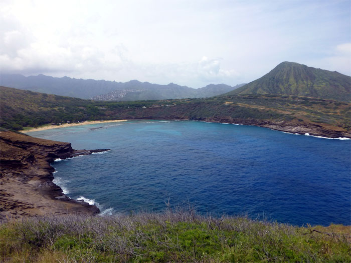
Kevin and myself exploring one of the numerous caves that dotted the coastline. Photo by Chris Hiona.

The other side
We briefly considered trying going through the cave, but decided to contour around the rocks instead. There is even some kind of bizarre goat skulls lookout on top of these rocks!

Jumbled rocks
There was one rock formation jutting out into the ocean that forced us to time the waves so that we could safely pass around it. It would also help to have tabi’s or reef walkers while walking on these slippery slabs of rocks, we just had to take it slow and safe.

Wave action
The waves were pounding the rocks today. Never turn your back on the ocean as the waves and currents can drag you out in the blink of an eye. On top of that, we were hiking during high tide!

Hello there!
The waves over countless and repeated poundings gave this area it’s unique carved look.

Spitting Caves
No spitting today. Didn’t see any jumpers willing to take the plunge from where Chris and Kevin are standing at. I heard you have to time it just right. There have been drownings in this area and China Walls over the years.

Leaving civilization behind
Leaving behind the million dollar homes with the million dollar views as we ascended up Koko Head.

Headed up Koko Head
As we were climbing up, there was a commotion in the water behind us. It turned out to be several whales breaching the water, quite the show.

Paraglider
We saw several paragliders catching thermals off the rocky skin of Koko Head and circling and skimming above our heads.

Circle of LIfe?
Top of Koko Head.

Makai bound
Walking down the clearly marked trail and leaving the communication towers behind us.

Honeycombed rocks
As we made our way down towards the ocean, we met a mountain biker who was coming up! Talk about making your own trails.

Land Bridge
Three of us sitting on this often photographed land bridge with the water churning like a washing machine below us. It seems to have become quite the spot to get your picture taken at lately. We were no different.

Koko Head Marker
Taking a pose next to this weather beaten obelisk with Koko Crater and Makapu’u in the background.

No charge for locals
Chris showing us the “back door” to get into Hanauma Bay.

Forgot our snorkels!
Here we are in the clear and cool waters of Hanauma Bay and no snorkels!

Coned off
As we walked up towards the parking lot, we noticed an Hawaiian monk seal sunbathing on the sand, oblivious to all the attention it was gathering from the beachgoers.

GPS Tracks
The 4.24 mile hike was a fun little excursion. Time well spent.
{ 13 comments… read them below or add one }
Can you please give me specific details on getting to the land bridge? Didnt see it on my hike today.
Hello,
If you’re coming up the road on Koko Head, take the trail that goes down towards the ocean. You should have Hanauma Bay on your left as you’re going down. Continue further down until you see a large bush and then go down to the ocean and you should see the shelf and the land bridge to your right. Hope this helps!
Kenji~
With the help of your directions, I was able to venture out to see the bridge on 2 different occasions. Thank you! Unfortunately, both times the tide was too high. Wasn’t able to walk on the br bridge.
Aloha Jus Mei
Glad you were able to find the land bridge. Yup, it’s better to be safe than sorry! The land bridge will always be there! Hope you see it at low tide if you try again!
You’ve peaked my interest on seeking out the cave with a pool of water and goat skulls. would I be able to get directions to that destination?
You can email me at rmeilingy70@gmail.com
Thank you!
Hi i really want to do this hike tomorrow and mainly want to go to the land bridge thing and maybe the cave.i have never been before and just wanted to know if you could point me in the right dire tion. It is my birthday tomorrow bout i cant seem to find someo e who has been there. Please get back to me by email kawaiola143@gmail.com
Hi Brandi
I sent you the directions to your email address and partial GPS tracks, even though I don’t think you need them. Just make sure you start at low tide, check tide tables.
Have a Happy Birthday, be safe and have fun!
First off, epic shots here, well done! As for China Walls, it’s an amazing place to see in person, but not a place to swim. And stay away from the edge so rogue waves don’t knock you in. More at: https://lookintohawaii.com/hawaii/4186/koko-kai-mini-beach-park-china-walls-beaches-oahu-honolulu-hi
Aloha Matt,
Thanks. Yes, good advice as one person just recently passed away and many others still get washed off.
Mahalo
So I tried to find the caves yesterday and failed. I think I went the wrong way. I almost ran into a sleep monk seal! I was there an hour before high tide so maybe that’s what I did wrong. Was wondering if you could send the directions to the cave please? Thank you in advance. Mahalo????
Aloha Lisa,
To clarify, you just want to go Spitting Caves? The easiest way is to simply drive almost to the end of Lumahai Street. The trail is marked with a couple signs, sandwiched in between two houses. Stay clear of the cliff edges and please be respectful of the neighbors in the area.
Mahalo
Aloha. Sorry I meant the one that you have on the picture above that said “cave exploring” and “the other side”. Where is that? Mahalo.
I will email you regarding what you requested.