
Back in the saddle again. A heavy soaking the day before had actually aborted our saddle hike. However, after going all over the board with alternate hikes to do, we ended up doing the saddle anyway. The skies were clear, so despite the weather sometimes changing on a dime up in the mountains, we decided to take our chances. Photo by David Johnson.

Burmeister Overpass
We carpooled to the end of Kalihi Street to minimize our footprint, as ever since Naohia Falls has been shut down, the neighbors have been quick on the telephone draw. After quickly making our way up the side road, we crossed over the Burmeister Overpass and headed up to the spur ridge.

Bowman shortcut
The Bowman shortcut shaved three miles off the traditional trail, but we paid for it with buckets of sweat. Okay, maybe not buckets, but at least little teacups. The ridge was short and steep and the humidity level was high. No signs of surveyors today.

Bowman trail
Enjoying the easy part of the hike while it lasted, which was about three miles.

Little green men
I always wondered who leaves these plastic soldiers behind, as they are scattered on trails throughout the island.

Mr. Bowman
Thessa crossing over an eroded trail section, with the prominent knob that resembles a face (see the “eyes” and “nose”?), looking down at us.

Kalihi Saddle
The cloud deck started to get lower and darker over the saddle. Pretty please, don’t rain on our parade.

Needs a name
Climb this rock and get the right to name it, much like Griego Wall and Dorito Tower. Just kidding. It already has a name. That big piece of rock sticking out of the hillside.

Climbing the knob
Switchbacks made it easier to climb up the knob. No straight shot to the top.

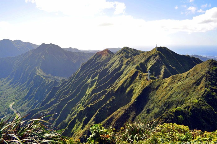
Panoramic view of the Leeward side
Clouds started to roll through the saddle, which still left clear views of town. Photo by Jose Luis Delaki

Meadow
Jose and Thessa crossing a grassy meadow near the summit.

Bog
The top was home to a bog, similar to ones found at Ka’ala and other high spots on the mountains.

Pu’u Kahuauli
Cloudy summit at 2,740 feet. At least we could hear the cars on the highway down below us.

What’s over that peak?
After taking a short break at the summit, we made our way over this small peak that leads to the saddle.

No turning back
Group photo back to front: Jose, Thessa and myself.

Into the clouds
Hiking into the clouds.

Windward side
Jose contouring around the Windward side of the ridge.

There’s the saddle
As we dropped below the cloud deck, the saddle popped into view.

Slightly eroded
A taste of what was in store for us.

Stay high
Spikes definitely helped to grip the crumbly and eroded ground as we made our way down the saddle.

Say cheese
Now the fun begins. Photo by Thessa Bugay.

Shaky tree
Hmmm, what is this tree for?

Going down
Oh, to help us climb down the side of this crumbly ridge. The tree was shaking the whole time Jose was climbing down and it looks like it could pull out one day. Maybe we should bring it some Miracle-Gro. Photo by Thessa Bugay.

Clear
Thessa making her way down. We had to space ourselves apart, especially when down climbing the heavily eroded sections, as rocks and dirt would get dislodged. None of us were wearing hard hats.

Got room?
The winds were noticeably absent. That was a good thing. Usually I welcome the brisk trade winds to help cool off. Not today.

Checking out the views
The views, when the clouds cooperated, were just to die for. Sorry, poor choice of words.

Left or right?
Jose and Thessa went down the left side that had the vegetation. I decided to see if my spikes would hold me coming down the right, rocky side. They held.

Getting lower
The HECO building at the base of the saddle seemed so close from so far up. The summit of Lanihuli seemed so far away, capped in clouds.

Climbing down
Thessa climbing down a pile of rocks. Most of the rocks on the saddle looked fractured and split, ready to come off at the wrong time.

Getting cloudy
Never a dull day on the saddle.

Grassy spot
The angle makes this part of the ridge look ready to fall off one day.

Dirt triangle
Thessa climbing down from the “dirt triangle.” Fellow hiker, David Concepcion, named the obstacle when he last did the saddle.

Wide open area
Looks wide from this angle.

Clouds rolling in
And skinny from this angle. All about perspective.

Somewhat narrrow
Huge drops on the Windward side. Actually both sides.

Are we having fun yet?
Yes. Why else would we be hiking on a severely eroded ridge? Photo by Jose Luis Delaki

Mahalo for the ropes
Many thanks to the hikers that have left ropes on this trail and shared advice on this hike. The ropes and/or anchors that are here today, may be gone tomorrow. Trail conditions change frequently, especially on this saddle. Hikers that have done it, always seem to report that the saddle becomes more eroded with each visit.

Don’t let go
Thessa looking for a place to land her feet. Maybe we should have come down the right side. Oh well, we all need a little challenge every now and then.

Best seat in the house
Seats single file only.

Balancing act
No margin for error.

Narrow ridge
Most parts of the ridge had to either be “saddled”, crawled, scooted or skirted on the side with precious little purchase beneath our feet.

Another perspective
Looking back at the saddle.

Is this rock safe?
The answer is no. The rock wobbled when we pushed it.

Don’t pull on the webbing
We didn’t rely on the webbing going down as we didn’t want that rock landing on our heads. Talk about a bad hair day.

Crossing the ridge
Jose crossing a mini-saddle on the saddle. Well, that’s what it looked like to me.

Coming down the mountain
Thessa coming down the saddle, with the most difficult sections behind us.

Too early for trick or treat
Jose approaching the last obstacle, dubbed “Witch’s Hat” by hiker, Pete Clines.

Scooting
Thessa coming over one of the last “humps.”

Witch’s Hat
The base of the “hat” was somewhat steep and then leveled off to a “walkable” grade.

Leave the webbing behind
Thessa coming down the backside of the “hat.” Jose donated his webbing to the saddle. Gracias.

No climbing involved
Jose contouring around the Windward side.

I want to go back up
Not today.

All pau!
Just as we made it down to the power lines, the clouds released her rain. Perfect timing.

Goodbye Kalihi Saddle
Until we meet again. She was a lovely ride.

Hitchhiking to Kenny’s
Shout out to Chris and Brian for picking us up on the side of Likelike Highway. What’s for dinner? Prime Rib! Photo by Chris Hiona.

GPS Tracks
The 4 mile hike now ranks as my hardest hike to date. Many thanks to Jose and Thessa, who have done the saddle numerous times, for keeping me company on this trail. Would I do it again? Yup, but going up, as going down was a crazy albeit fun experience.
{ 7 comments… read them below or add one }
Congrats Kenji! Stoked for you. =)
I remember being on the island this day and wondering what you were thinking and what it looked like up there. Now I know.
Thanks Ryan! Props to you as well for doing the KST in one shot. Maybe one day, I’ll attempt that as well.
Mahalo!
Hey Kenji! Do you plan on doing the saddle again in the near future? (As in within the next year?) Or do you know of a group who is? I feel like this is a hike that if we had someone who has done it before it would be much better. Also do you have any news on how the trail is?
Aloha Elizabeth,
Ahh, you should have asked me earlier as we just repeated all 3 saddles within the past month. The trail is getting more eroded as it sees more traffic. I will probably do it again at least a couple more times this year.
Mahalo
Love your blog! I have been wanting to more of the less traveled hikes but don’t have anyone willing to do some of the ones like this. If you are planning any and willing to let me tag along, I’d love to join!
Thanks
Aloha Aiden,
Thanks. I’ll probably visit that part again, shoot me a message to stay in touch.
Mahalo
Shoots just saw this. Would have loved to go. Keep me updated