
Apparently I had not got my fill of hiking up steep Windward ridges, that is why I found myself with Chris going up Mariner’s Windward on Easter. Photo by Chris Hiona.

Finding the breadcrumbs in Waimanalo
We started off at the Tom-Tom trailhead and made our way through the Waimanalo forest as we crossed dry riverbeds and pushed our way through these green things called trees. By following the scattered pink ribbons and the GPS tracks that J let me have, we eventually made our way to the ridge.

I feel the need for micro-spikes
As the grade got steeper and the dirt become more abundant than those green things, Chris decided to slap on his micro-spikes for better traction. Once again, I found myself the lone man out.

Let’s go find some rocks
As we rapidly gained elevation on the ridge, those green things returned with a vengeance. I was so happy to break off from all that undergrowth when the opportunity presented itself and scrambled straight to the rocky ridgeline. Photo by Chris Hiona.

Nice day on the Koolau’s
Picture perfect conditions on the Koolau’s. Nothing is more rewarding than being able to see both sides of the Koolau’s as far as the eye can see. Photo by Chris Hiona.

The fun begins
After a bunch of picture taking, we resumed our hike up the rocky ridge. It did get steep in certain sections but there were ample footholds and handholds. Those pesky trees also provided convenient handholds as well. Photo by Chris Hiona.

Nice view of Waimanalo
Chris taking a break to soak in the views of Waimanalo.

The fun continues
We soon resumed our scrambling up the ridge. Photo by Chris Hiona.

Crumbly rocks
Crumbly rocks or choss seem to make up most of the rocks found on the mountain ranges in the islands. I was just about to warn Chris that this section was super crumbly, when all the rocks underneath me gave way and sent me sliding 30 feet down the mountain. Luckily those pesky trees arrested my fall.

Better view of Waimanalo
Chris taking in the higher elevation views of Waimanalo. These views never get old for me.

This is where the real fun begins
As we sized up our next major rockface that we had to climb, we spotted the only rope we saw during our entire hike up the ridge. That must mean something, right?

Panoramic view of Waimanalo
Click here for the larger image.

Made it!
Sometimes the direct way up doesn’t click for me. Figuring that was too hard, I decided to scoot my way around the crumbly and narrow ledge to contour my way around the rockface and climb up. Chris decided that was not the path he was going to follow and after some effort, finally made it the direct way up. He made the right choice.

Is this rope safe?
After Chris climbed up the ledge, I swung the rope over to him to give him some assistance climbing up. I don’t know how long that rope has been there, but the outer layer was frayed and coming off in copious pieces. Most of which flew into my nose and mouth, not very appetizing.

Last hump to the top
We crashed our way through some more thick undergrowth, which led Chris to lose his camera boom. After that, it was a quick scramble to the top.

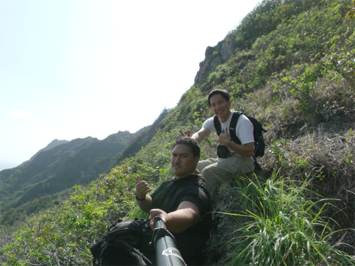
Mariner’s Windward Ridge
Top of Mariner’s Windward Ridge. Photo by Chris Hiona.

Mariner’s Ridge Summit
Top of Mariner’s Ridge with great views of the Koolau’s and Olomana in the background.

Hawaii Kai in the background
The original plan was to continue the hike to Makapu’u, but Chris started cramping up as we made our way up the ridge, so we decided to end it by going down the Mariner’s Ridge Trail.

GPS Tracks Mariner’s Windward to Mariner’s Ridge
The entire hike was a little over 4 miles and Chris decided not to go back down and get his camera boom. I don’t blame him.
{ 5 comments… read them below or add one }
Awesome write up! I was recently looking @ certain pics..Lol..I kinda miss my boom…lol..
Thanks Chris! Always looking for the next adventure! Perhaps Makapu’u down to Mariner’s Windward where you can retrieve your boom? lol…
Nice write up – have been meaning to do this one. Do you remember if the path is marked well enough to follow without GPS?
Thanks Nate. The trail was marked with scattered pink ribbons. I think if you just keep tracking towards the ridge, and once you hit the ridge, it’s straight up! If you like, I can send you the GPS tracks. LMK. Aloha!
I think we’ll try it without the tracks. Your map screenshot should eliminate any guesswork. Thanks for the offer though – mahalo!