
Originally we had a group of three to hike Pu’u Kalena, Oahu’s second highest mountain at 3,504 feet located on Schofield Barracks. One bailed to go kayaking instead, on that scorcher of a day, I’m not sure who made the better choice. We drove through Lyman Gate after showing our papers and were given a day’s pass to roam Schofield Barracks at our leisure. We drove straight down Lyman road and turned left on KoleKole Road passing housing, motorpools and military ranges. We parked at a small clearing to the left just before the KoleKole Pass gate and walked across to road and passed two concrete blocks that marked the start of the trailhead.

What trail?
We made our way up the dirt road and came across this rocky and crumbly section of the mountain. We just followed the path of least crumbly rock resistance.

Good morning Wahiawa!
After only 15 minutes of huffing and puffing, we saw the sun warming up Central Oahu.

No ropes here
Climbing up the mountain, we noticed that Pu’u Kalena is one of the few hikes that ropes are noticeably absent on the trail. Also with today being Memorial Day, the military’s guns were deafeningly silent.

The first peak
After passing a narrow dike section, we made the first peak in about an hour. There are two false peaks that must be climbed, before starting to tackle the last peak of Kalena.

Break area
Climbing down from the first peak into a saddle that goes into a valley, we took a short breather on somebody’s home made bench. Must have been an Eagle Scout.

Second peak
After getting our second wind, we climbed out of the saddle to a small hill and went back down another saddle before going up the second peak.

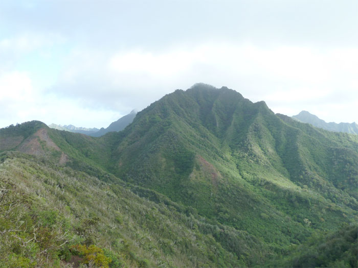
Mount Ka'ala
Pushing up to the final peak of Kalena, we saw one of the few ropes on the trail. The heavy vegetation seemed to mask the steepness of the climb, as it didn’t seem all that bad. We made the top in a little over three hours.

Waianae coast
The views from the top were stupendous, with sweeping views of the Waianae coast and Mount Ka’ala. We signed our names in the guest log that was hanging from the moss covered ohia tree. The log is actually just a Post-It pad in a thermos.

Going back down the dike
After soaking in the views and grabbing a bite to eat and drinking warm water, the hardest part of the hike lay ahead. The trail going back down to me is the hardest part of any ridge hike.

Kolekole Pass Road
After making our way back down the trail on wobbly legs, we came across the rocky and crumbly section, where sliding on our feet and okoles was the fastest and safest way to get down back to our cars.
{ 3 comments… read them below or add one }
Brian wants to hike Kalena.. so I’ve gotta research just in case..lol..
Let me know if you want company, it’s been over two years since I’ve done it and I still need to get GPS tracks for all my earlier hikes, this being one of them.
Ok Rahjah!
{ 1 trackback }