
I joined Marvin, Les, Lita, Matt and Robb on a “baby grinder hike” (Marvin’s words) from Aiea to Red Hill, with a descent into Stairway of Hell.

Keaiwa heiau
We stashed a couple of cars outside of Moanalua Valley Park and carpooled in Matt’s van to Aiea Heights. It is highly recommended to park outside both parks, as there is a strong chance that when you come down that the gates will be locked. The 17th century ruins of an Hawaiian healing temple was near the entrance of the Keaiwa Heiau Park, as we followed the road in.

Trailhead
The road led us to the top of the Aiea Loop Trail, where we also picked up Robb to round out the hiking crew.

Bench with a view
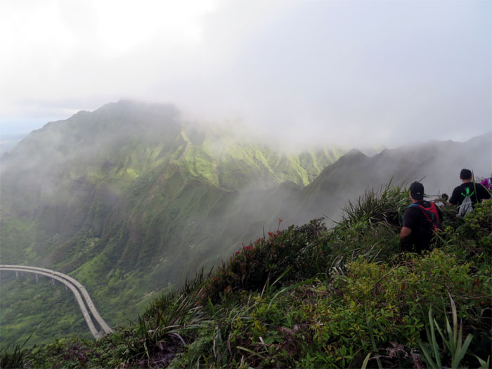
The trail sees heavy use by two legged and four legged hikers.

H-3
If you see the H-3, you went too far. Backtrack a bit and make a right up towards the ridge.

Halawa valley
Paralleling the H-3 as we made our way up Aiea ridge.

Looking back
The last clear view we had as clouds soon enveloped us on the ridge.

Powerlines
Looking ahead at the false summit which is marked by a massive powerline tower.

On the KST
We soon topped out on the Koolau’s. What a view! What view?

Cloudy views
Making our way on the narrow trail choked with vegetation, typical KST trail, the clouds would teasingly break apart to give us Windward views and take it right back.

Hawaiian mint
Marvin pointed out this endemic flowering plant, also known as Phyllostegia glabra.

Hiking in the clouds
Hiking in whiteout conditions is surreal and a bummer as no views are present.

Protected area
This small fenced area affords protection to a rare endemic bellflower plant known as Cyanea st.-johnii, that only grows on the Ko’olau Mountains. Didn’t see any today.

Partly cloudy
We can see again!

Rolling mountains
The cloud cover lifted her veil for a moment to reveal the Ko’olau Mountains in all her glory.

Ohia lehua
A red lehua blossom on an ‘ohi’a tree.

Sliding down the ditch
Making our way down the summit trail, we eventually scooted down a ditch where the hidden stairs soon popped into cloudy view.

North Haiku Stairs
Visibility was zero at the top of the stairs. The last time we were here, I had wanted to go down to the end of the stairs, but time constraints dictated otherwise. Was today going to be different?

Look to the left
As I dropped in elevation going down the stairs, the Windward views opened up.

Look to the right
Clouds hanging over the Ko’olau’s Mountains.

Stairway to Hell
Going down the stairs is a different experience than Stairway to Heaven, as railings and steps are missing or rusted to the point of dust. Gloves are highly recommended. Vegetation has reclaimed most sections. The stairs abruptly end at a steep cliff section, a view that was denied to me again. I think I got within a hair of the end, but Marvin called and said the group wanted to leave. Guess I’ll be coming back for another visit.

What goes down, must come up
I raced back up the stairs as fast as my legs and the stairs condition allowed me.

Leaving hell
Got back to the top of the stairs and was gassed out. Munched on my musubi and guzzled some water and then we headed out to catch up with Lita and Robb who had left earlier.

Geo Marker
No views again at the geo marker spot, as we made our way down the summit trail.

Halawa junction
Group photo clockwise: myself, Lita, Robb, Marvin, Lester and Matt. Photo by Matt Vidaurri.

Going down Halawa ridge
Lita and Robb decided to part ways and go down Halawa Ridge due to concerns about hiking in the dark.

Over the H-3
We picked up the pace as we resumed our hike on the summit trail, passing the H-3 directly overhead.

Red Hill junction
Taking a short break in the clouds.

Long and flat
Going down Red Hill Ridge was defined by a couple big hills and then roller coasting over smaller ones.

Going down the Godek-Jaskulski Ridge
We eventually turned left and made our way down to Moanalua Valley.

Kulana’ahane Trailhead
Time to break out the head lamps for the three mile walk back to our cars.

GPS Tracks
Baby grinder my butt! The 13.03 mile hike over the rolling mountains of the Koolau’s resulted in a long day filled with clouds and intermittent views, but still a great way to end the day or should I say night?
{ 8 comments… read them below or add one }
Great hike. We are doing the last section from Kam Schools to the that side of the Likelike saddle then we have done the entire summit from Tom Tom to Pupukea .
Howzit Joe,
Great job, soon you will have hiked the entire Ko’olau spine from Pupukea to Makapuu! Have fun!
Mahalo
Looks like an interesting hike! Thanks for sharing!
Aloha Lonnie,
Thanks for dropping by and glad you enjoyed the post. Stairway to Hell is a very nice hike if you make the time and effort to get there. The views are hands down, out of this world if the weather cooperates!
Mahalo
My wife and I did from Tripler to the stairs, it was a beast of a hike. This looks a lot less intimidating. Was it mostly ridge line or path way. I’m scared of heights which is what made crossing the ridgeline from the powerless to the east of the stairs so hard for me. It looks like on this path, you’re seeing things that only a handful of people ever experience. Amazing!
Aloha Mario,
In my opinion, subjective and all, this hike is harder than the Tripler hike. This is for the most part on the ridge which in most sections are crumbly and in some parts very narrow, leaving little margin for error. If you are scared of heights, I would not recommend you do this hike as this one puts you literally on the edge with steep drop offs on both sides.
Mahalo
I attempted this hike yesterday August 21st 2019 and I got to the “protected area” picture. The clouds were extremely dense and was soaked From head to toe. I tried to navigate my way using ur pictures, but I couldn’t find my way down where u guys are sliding down that ditch. I couldn’t find any resemblance of the picture.
I saw your posts on facebook and what Dylan cotton said was what most likely happened. There is a junction where you probably turned right instead of staying straight on the ridge that would’ve took you to hell. That right turn you took just takes you down a spur ridge to nothing. In socked in conditions, it’s easy to get lost. Better luck next time.