
Good weather beckoned us back to the mountains. The Waianae Mountains. We picked up where we left off from last time. Photo by Steve Lin.

Kealia Trail
Jame’s wife was nice enough to drop our group off at the Kealia trailhead. A dog even greeted us as we got ready and then bounded off to her master that was ahead of us. We would see her again. Soon.

How many switchbacks?
Thessa and Marvin cutting across one of 19 switchbacks that makes up the trail.

Hot? Thirsty?
Look who we ran into again. The same dog that greeted us at the beginning. She must have got separated from her master and was panting like a dog. Steve gave her some of his water to cool down. Where was her master?

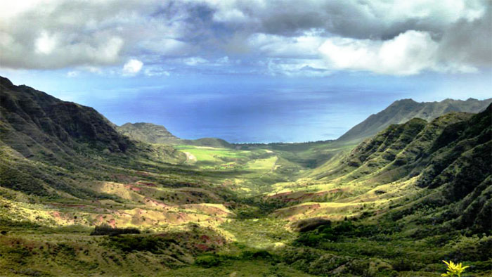
Mokuleia
The higher we got, the better the views.

No more switchbacks
Thessa making her way to the picnic table at the top. What, no food?

Wide open
After a short break at the top, we continued on the trail towards Ka’ala.

H20
Not all tagging is an eyesore. Photo by Thessa Bugay.

Duck!
Passing the bullet riddled sign announcing the Kuaokala hunting area. Seems all hunting signs are marked in this fashion.

Kuaokala Trail
The trail soon turned left.

Are we hiking?
The wide open and relatively flat trails made it less of a hike and more of a stroll.

Follow the signs
We continued towards Mokuleia trail. Still no sign of the dog’s master. Perhaps he went to the AF tracking station?

Right is right?
The trail soon forked. We took the high road. Which led us to this…

Scenic point
A somewhat obstructed but still fantastic view of Makua Valley. Training grounds for the U.S. Army.

Back on the road
We dropped back onto the dirt road.

Makua Valley
The trail contoured around the rim of Makua Valley, opening up the views.

Mokuleia
Looking out towards the North Shore.

Going up
The trail started to drop, so we took this other trail leading back up top.

The fence
Seeing a familiar sight on the Waianae Summit Trail, the fence line.

Moku
All feet on the marker. We turned right at the marker to continue our hike. Going left was a bailout trail.

No dogs
The maze of fences that crosses the Waianae Mountains are the result of the Oahu Army Natural Resources Program. They want to give back by helping save endangered fauna and flora for taking away large chunks of land for their training.

That way
Thanks to Steve for pointing us in the right direction.

Pahole
Entering the 685 acre natural area reserve that protects endemic fauna and flora.

Say what?
Explosives in a nature preserve? To take out the invasive species?

Fence crossing
We never did spot any of the endangered fauna and flora. But we weren’t looking that hard either.

Scenic point
This was a breathtaking spot to soak in the valley views. Click here for the larger image. Photo by Marvin Chandra

Back to the fence
After leaving our scenic spot, the fence line splits. We took the right fence line to continue to Ka’ala.

End of Mokuleia Trail
Group photo back to front: James, Steve, Marvin, Thessa and myself.

Down the fence
James following the fence line down.

Just follow the fence
Thessa following the fence line up. Then back down.

Mokuleia
We arrived at Three Corners; roughly 2,600′ in elevation, affording some of the best views on the island.

Makua Valley
Looking into the lush green Makua Valley, it’s hard to believe it was once blackened and scarred by military live fire training.

Makaha Valley
If you listen hard enough, you can hear the crying peacocks in Makaha Valley.

Straddling the fence
Some were more graceful than others when crossing over the fence to continue the hike.

Mount Ka’ala
Thessa making her way down the ridge which soon terminates, forcing us to drop on the road to the left. Now how do we get down?

The hard way down
Someone, who will go unnamed, said this was the way down. I wouldn’t recommend it as it was quite steep and crumbly coming down. Steve and James soon followed me down, dislodging small rocks onto the road.

The easy way down
The trail to come down was actually further up the ridge, marked by a patch of uluhe ferns. The original plan was to continue the road to Ka’ala and go down the Waianae-Kai trail. Plans change. We decided to just continue down Ka’ala road.

Mirror selfie
Staple of road hiking. The mirror selfie. Photo by Marvin Chandra

The long road down
Five miles of paved road. At least it was going down.

Mama pig?
I saw this little pig pop out of the trees and warily looked for a protective mama, luckily the pig went back into the tree line.

Don’t have to worry about this guy
Cows are safe with Marvin.

Cattle proof?
There were a couple of these crossings that had wide spaced bars to prevent cattle from moving up the mountain.

Can see the ocean
A couple of miles into the road, and the views of the mountains were replaced by the ocean. Getting closer.

Chicken adobo?
Just looking for a hand out.

Belly rub
A friendly dog greeted us. All she wanted was belly rubs. Photo by James Crabb.

Paved road ends
Steve about to make the transition from the paved road to the rocky dirt road. Less hard on the feet.

Go home
The friendly dog wanted to follow us home, until James scolded her and she turned around.

Until next time Mount Ka’ala
Mount Ka’ala beckoned for us to come back. Another day.

GPS Tracks
The 13.6 mile hike started off with a dirt road and ended with a paved road. That probably made it quite easy despite the distance. Many thanks to Jame’s sister for picking us up on the side of the highway. We all had some good pizza at Jerry’s Pizza in Waialua for dinner. Beverage tip: If you need real Coke, you have to go to the store and get it.
{ 2 comments… read them below or add one }
Awesome blog Kenji. Always looking forward to read about your hiking adventures. Thank you!
Hey Thessa,
Thank you for coming on the hikes, you always make it awesome!
Mahalo!