
Stuart Ball called Ohulehule southeast ridge “the most dangerous hike on the island.” While I wouldn’t necessarily agree with that statement, I would say it’s one of the more physically taxing hikes.

Haupoa Street
Aaron, Darren, J, Marvin, Matt, Troy and myself joined Will on his hike today. Matt staged his truck in Kahana Valley and we all met up in Waiahole.

Where do we start?
Right off the bat, there was some confusion as to where the trailhead started.

Found the trail
After finding a passable trail through the forest, we started following this heavily eroded section to the ridge.

Are we on the ridge?
No views yet.

Looking back
Will and Marvin scrambling out of the forest.

Scenic point
The exposed ridge offered views of Hakipu’u Valley, Pu’u Kanehoalani, Mokoli’i and the Moli’i Fishpond (which is one of four original Hawaiian fishponds left extant on Oahu).

Rock climbing
Our first dike on the ridge. One of many to come.

Hanging out
Darren enjoying the views. Pu’u Manamana and True Manamana are visible beyond Pu’u Kanehoalani.

Southeast ridge
The dikes offered a respite from the heavy overgrowth on the ridge.

Not too steep
We just had to watch our step, as there were drops to our right. No drops to our left.

Ridge hiking
The surrounding views made it all worthwhile.

Where’s a weed whacker when you need one?
We had to plunge into heavy ridge overgrowth which plucked my GoPro from my backpack. Lucky for me, that Darren found it hanging on a tree. I still owe him a soda. Yes, I’m cheap.

Panoramic view
The views from this valley have few rivals on this island. Just an opinion. Click here for the larger image.

Rocks are preferable
J climbing down a dike. Much easier than battling the annoying and cloying overgrowth. Shortly after this section, Will and Marvin turned around, as Will was not feeling well. It’s always good to know your limits, I have cut a hike short before due to not feeling well. Better than ending up on the six o’clock news. The mountains will always be there.

Pu’u Ohulehule
The summit was still cloud free. How long would that last?

Clouds moving in
The cloud deck was capping Pu’u Manamana.

Use the tree
This particular dike was a little tricky to get up, a nearby tree served as a stepping stone. Aaron opted for the “pincer” hold.

Getting steeper
The ridge started to get steeper as we approached the summit. As we contoured on the Leeward side, the old adage about not trusting ropes, rang false. Matt was holding onto a tree when it gave way and the only thing that kept Matt from plunging down was the rope in his other hand.

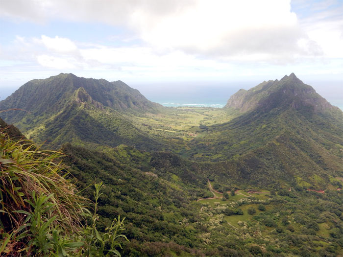
Panoramic view
The valleys of Ka’a’awa and Hakipu’u split by Pu’u Kanehoalani. Click here for the larger image.

Windward view
Looking back at the ridge we had come from. This route used to be on the HTMC schedule, until legal access became an issue. Stricken from the hike list.

Boulder fun
We contoured to the right of a large boulder that was blocking the trail. Photo by Aaron Toma.

Pushing up
Now the fun part. Not really. The rest of the climb was at a steep pitch that involved pulling yourself up. Ropes helped. Considerably.

Almost there
More uphill climbing.

Summit view
J was the first to summit Pu’u Ohulehule and was rewarded with a clear view of the valleys. Click here for the larger image. Photo by Francis Joy.

Cloudy summit
This is the view that the rest of us got. Group photo left to right: Matt, Darren, Troy, Aaron, myself and J.

Going down
Going down northwest ridge, the traditional route to Pu’u Ohulehule. The initial descent was somewhat steep, but soon slackened off.

Dangerous trail
Hmm, I’m glad we’re going the other way. Maybe this was the section that the two Danish girls got stuck back in 1999. They spent an amazing eight days on this ridge before HTMC members found them.

Cloudy peak
Looking back at the 2,265′ summit wrapped in clouds.

Panoramic view
Looking left to right: Pu’u Piei, Pu’u Manamana and Pu’u Kanehoalani. Click here for the larger image.

Can you smell what the rocks are cooking?
Close up view of True Manamana and Two Apes Talking rock formation.

Kahana Valley
As we made our way down to the valley, the rain started.

Say Ahhh!
Troy ran out of water, so Mother Nature helped him out.

Fern country
Uluhe ferns seem to have colonized most of the trails.

Stream crossing
The group taking a break at the first stream crossing. Troy helped himself to free water.

Where’s the dragon?
Awhile back, this area was burnt by fire. It left behind a blackened tree that looks like a dragon. Can’t see the dragon for the trees.

Follow the ribbons
Troy about to cross the second stream. Still only ankle high.

Stroll in the forest
The thick canopy of trees filtered much of the sunlight that reached the valley floor.

Shrinkage
Water level was waist high at the third stream crossing. Ice cold.

Nakoa Trail
Left? Right? Straight!

Dam crossing
There was a rope hanging near the dam. Matt was the only swinger today.

Road out
Marvin and Will met us at the end and ferried us to our cars. What? No ice cold drinks waiting for us?

GPS Tracks
The hike was only 5.52 miles, but as Aaron put it “You earned every inch of it.” Great hike with familiar faces that I haven’t seen in awhile. Post hike meal was at El Mariachi in Kaneohe. BYOB.
{ 16 comments… read them below or add one }
Good one Kenji! I drank the stream water and never got lepto. Remember to steripen or drop tabs!
Howzit Troy,
Always great hiking with you! Until next time!
Mahalo
Hey Kenji,
Where does this trail begin and how long is it to the top to where you can see Chinamans Hat?
Thanks,
Aloha Craig,
I will email you separately and it takes an hour or less to get to what some people are calling pride rock.
Mahalo
What’s up dude, can you email the same info that Craig requested? Also where do you park? Thanks!
Aloha Blaino,
I will email you under separate cover. Parking is a bit of a problem, best if somebody drops you off.
Mahalo
Thanks for the awesome and detailed blog. Attempting this one next weekend! We tried it a few weeks ago starting the way you finished up, but we lost the trail pretty early in and had to turn around. Going to try your route this time. Do you remember approx how long the hike took?
Aloha Katie,
Thanks and good luck on your hike. Hope the weather cooperates. It was roughly 10 hours, of course your time will depend on your group size and pace. Stay safe and have fun!
Mahalo
HTMC scheduled it last in 1985. No one fell off and died. Rather someone was coming down, and dislodged a big rock. I was on the dike below still going up. I thought somebody fell of and died, but no, only a big rock. That was the last time it was scheduled. They said the reason was they could not get legal access.
-Wing
Aloha Wing,
Thanks for the clarification. I thought somebody from HTMC told me that. But glad to hear that nobody died on that trail. That trail is now popular because of that rock formation before the “hard” parts, they call it “Pride Rock” and droves go out there now to take sunrise pictures and go back down. Thanks again for the info.
Mahalo
Hey great info! Would you mind forwarding the same information you sent Craig to myself as well?
Thank You!
Aloha Lindsey,
Will forward the same info to you later on tonight.
Mahalo
Hi could you forward that same email you sent to Craig. Also could you explain the parking situation as I can not get dropped off.
I’ll send you the info later tonight.
Mahalo
Good day sir! Respectfully requesting the same information in regards with starting path and parking issue. Thanks in advance
Okay, I’ll try to send it out this week.
Mahalo