
Rain rain go away, come again another day. That childhood nursery rhyme was going through my head as I pulled in Wa’ahila Park at the top of St. Louis Heights to be greeted by morning showers. I met Jason there, as Glenn had bugged out due to the rain. We talked about it and hoped the rain would pass, so we got into my car and drove to Hawaii Loa to start our hike at 7:15am.

Going up Hawaii Loa Ridge
As we made our way up Hawaii Loa ridge, the clouds seemed to be settling lower and lower on the Koolau Mountain tops. The rain had not followed us, but what we got instead was clumps of dirty water drops.

Hawaii Loa Summit
We got to the top of Hawaii Loa Summit at 2,520 feet in whiteout conditions. The views of Waimanalo and the Windward side of the island were nowhere to be seen. Not having anything to keep us at the summit, we proceeded to follow the heavily vegetated trail on the left.

Wailupe Middle Ridge
We hiked the Koolau Summit Ridge in the clouds and at times, could barely see in front of us. The top of Wailupe Middle Ridge harbored the same whiteout conditions we had hoped we left behind at Hawaii Loa. There was a little sign on the ground that pointed in the direction of Wailupe Loop, didn’t seem too stable as somebody or something could easily move the marker.

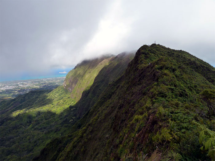
Wiliwilinui Ridge
About an hour later, we still had no view at Wiliwilinui ridge. But we did see the communication tower appearing out of the clouds like a pirate ship. I was beginning to think the whole hike was going to be in these conditions, a total bummer.

Diamond Head
A funny thing happend coming down from Lanipo where we had our lunch, the clouds started to clear up. As we made our way down into this little valley and climbed back out of it, the views started opening up, which gave us renewed energy to push on.

Mount Olympus
We could finally see our goal ahead of us, which was Mount Olympus or Awaawaloa.

Panoramic view going toward Mount Olympus
Click here for the larger image which shows the split views of the Town and Windward side.

Ka'au Crater
As we passed the two powerlines on the ridge, we saw the marsh filled Ka’au crater nestled against the Koolau Mountains.

We're coming Zeus!
Little wisps of clouds started rolling in from the Windward side, threatening to cover the summit. That made me push harder to get to the top as I didn’t want to miss an opportunity for a clear view from the top, something which rarely happens.

Olomana
Going up Mount Olympus, we had to climb a narrow and rocky ridge that was followed by a 10′ rockface and a somewhat steep hill. No ropes required.

Top of Mount Olympus
The top of Mount Olympus at a little over 2,400 feet was remarkably devoid of clouds, the last time I was here, there was zero visibility. The original plan was to continue until Manoa Middle Ridge and then double back. That would have completed the last part we needed to finish hiking the Eastern part of the Koolaus. But that idea was scratched due to lack of time and being plain tired on our parts. So we began the long descent down the Waahila Ridge trail towards our car.

Panoramic view of Manoa Valley and Town
Click here for the larger image of Palolo and Manoa Valleys.

The long trail home
Only twenty minutes until we get back to the trailhead (inside joke).

Need water!
We completed the hike in twelve hours, which was drawn out by being tuckered out and a tad dehydrated as we didn’t bring enough water. But how often, can you do three hikes all rolled into one?
{ 0 comments… add one now }